Native people of Kamchatka
July 29, 2008 at 1:39 pm | Posted in Maps, Naming, Siberia | Leave a commentTags: aleut, chavchuvens, chukcis, evenki, evenky, evens, History, itelmens, kamchatka, koryaks, lamuts, nimilans, nimilany, orochi, peninsula, russia
Some times you find out information in a weird way, as it happened to me last week. I was finding material fot the blog, and I ended up in a website with information of the native people of Kamchatka, a big big island in Russia. The surpising thing for me was that the site was owned by a travel agency! Anyway, it was a good starting, this is what they say:
Koryaks
The Koryaks are the main population of the northern Kamchatka part. They have their own autonomy – the Koryaksky Region. The name of this people as Krasheninnikov and Steller thought originated from “khora” – “deer”. But Kryaks don’t call themselves with this word. The coastal residents call themselves as “nimilany” – “residents of a settled village”. Nomads herding deer called themselves “chavchuvens“, it means “reindeer people”.
For the Chavchuvens reindeer breading was the main, even the only way of living. Deer gave them everything necessary: meat, skin for clothes (reindeer skin for coveralls, footwear) and for building of thansportable dwellings (yarangas), bones were used for making tools and household articles, fat – for dwelling lightening. Deer were a means of conveyance either.
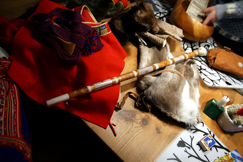
For the Nimilans the main way to survive was fishing. Fish was generally caught in rivers with the help of stinging-nettle (it took about two years to make one net and it was used only for one year). In settled villages marine hunting was the second way of surviving after fishing. Going out to sea on skin covered baydarkas was common. Harbor seal and whales became the target of harpoons, which were tied to the bow, and were killed with stone tip spears. Marine animals, skin was used for boat, ski covering, footwear, bags, sacks and belts. Domestic activities were highly developed – wood and bone carving, metal works, national clothes and carpets making, embroiling with beads, braiding. A lot of such works are displayed at the Museum of Local Lore. Tourists can admire the skillfulness of the masters. The Nimilans lived in groups: in winter – in half-dug-houses, in summer – in booths with their families, they used to catch fish, to hunt, and to pick berries. The Chavchuvens lived in temporary settlements consisting of some skin-covered yarangs. They used to herd reindeer and to dress skin. Hunting and fishing were of the secondary value for them. They migrated on dog- and reindeer-sledges.
Itelmens
The name of the nationality means “living here”. The south bound of settling is the Lopatka Cape. Northern one – the Tigil River on the west coast, the Uka River is on the east coast. Ancient Itlmen settlements were located on the banks of the Kamchatka (Uykoal), Yelovka (Kooch), Bolshaya, Bistraya, Avacha rivers and on the Avacha Harbor coast.
At the end of the 17 – beginning of the 18 centuries, when Russian explorers crossed the central part of Kamchatka, the Itelmens were at the level of disintegration primitive communal system development.
At the settlement consisting of a few half-dug-houses the folk Toyony lived. Some names of Toytony are written on the of Kamchatka. Itelmens life in summer was spent near some water resources and on them. They moved along the rivers in whole-carved boats made mainly of poplar. They caught fish with threshed nettle nets, built trapping dams. Some fish was cooked as yukola, some was burried for some time under the ground. But lack of salt didn’t allow to store much fish.Hunting was of the same value for this folk – fox, sable, bear, snow sheep; at the coast area – marine animals: sea lion, seal, sea otter. Also gathering was very popular (edible roots, edible and officinal plants, berries). Means of conveyance were made of birch (sledge and cargo sledge with soft belts). The ancient sledges were richly decorated.
The Itelmens ate a lot of fish, preferred baked one (chuprikh) and fish cakes “telno”, they ate young sprouts and runners of Filepinolium Maxim, Heracleum Dulse Fish (processed and ate them only after they acquired stinging power); as a medicine against scurvy they used cedar cones with dry salmon caviar chasing this mixture with tea. Food was seasoned with fat – favorite spice of all northern peoples. Women-Itelmens had a custom to wear wigs. Those who had the most luxurious and the thickest one was highly honored. Those fashionable women never wore hats. Young women did up their heavy black raven-wing-like hair in lot of thin plaits decorating them with small hair wigs in the shape of hats. Perhaps, that’s why the Chukchis and Koryaks might have called the Itelmens kamchadals, because in both languages the word “kamcha” means “curly”, “disheveled”, and “levit” or “lyavit” means “head”.
Itelmens clothes were extraordinary, they were made of sable, fox, snow sheep, dog’s skin with numerous ermine tassels and fluffy edged sleeves, hood, collar and hem. Steller wrote: “:the most beautiful reindeer skin coveralls (kukhlyankas) were decorated on the collars, sleeves and hems with dog’s fur, and on the kaftan (short reindeer skin coverall) was hanged with hundreds of seal’s tassels coloured red, they dangled to and fro at every movement”. Such Itelmens’ clothing made an impression of hairiness.
Evens and Evenky (tunguses)
The Evens and Evenky (tunguses) are similar by culture. The Evens ancestors having come to Kamchatka changed their traditional occupation hunting for reindeer breeding. Russians arriving to Kamchatka called the Evens roaming from place to place along the Okhotsk seaside “lamuts”, it means “living by the sea”. Herdsmen they called “orochi”, it means “reindeer men”. Beside reindeer breeding and hunting the coastal Evens caught fish and hunted marine animals. For fishing they made different kinds of dams and traps. Blacksmith’s work was very popular with the Evens.
The Evens did not wear blind clothes like the Koryaks, Itelmens and Chukcis did, but unlacing ones. Complete set of a man’s wear consisted of a short knee-reaching reindeer parka with running down lapels, trousers, a chest apron put on the parka, knee protectors, furstockings and boots made of reindeer led skin with soles of bearded seal skin. Wearing especially women’s one was decorated with beads. In contrast to other natives of Kamchatka the Evens didn’t use dogsleds and didn’t wear blind clothes.
Chukchis
The Northern Koryaks’ neighbours were the Chukchis, “reindeer men” (chauchu), some of them moved to Kamchatka. As for the household the Chukchi were like the Koryaks – reindeer breeders. A holder of less than 100 reindeer was considered poor and couldn’t keep a herd. Unfortunately, history of these two peoples’ neighbourhood knows a lot of examples of wars for herds. The Chukchis are native Kamchatka people, now a lot of them live here. Like the Koryaks there were the Chukchis who lived in settled villages and provided their living by fishing and hunting for marine animals. The Chukchis are perfect seamen skillfully operating boats on a cold sea. It is well known that their “fleet” used to trade with the Eskimoes launching towards the American shore. Main hunting implements were a bow and arrows, a spear and a harpoon. A bow and a spear were used in hunting for wild reindeer and snow sheep, a harpoon and a lance – in marine hunting. Arrow-, spear- and harpoon-heads were made of bone and stone. In catching all water-fowl and game the Chukchis used bola (an instrument for catching birds on the wing) and pratsha (a military weapon either). The protection armour was made of antlers, walrus’ skin and tusks. Main Chukchis‘ means of conveyance was reindeer, but like the Koryaks and Itelmens they also used dogsledges. On the sea the Chukchis moved in kayaks accommodating 20-30 men. With favorable wind they used square sails made of reindeer suede (rovdugas) like the Koryaks–Nimilans, and for a better balance they tied to board sides stocking-like sealskin, which was filled with air.
Aleuts
The Aleuts – ancient Aleutian Islands natives. They called themselves “unangan”, it means “seaside residents”. Main traditional Aleuts‘ occupations were hunting for marine animals and fishing. For winter the Aleuts stored eggs from birds colonies on the seashore.
The dwellings of the Aleuts were similar to the traditional half-dughouses but slightly different. Among the household articles there were baskets, bags plaited from grass; for storing of fat, yukola, crowberries with fat and so on dry seal stomach was used. On the Bering Island dogsleds became a very popular means of conveyance. For wandering in the mountains the Aleuts of the Medny Island used broad skis covered with seal skin for the nap would help while climbing not to slide down from the mountain.
Did you read that? Aleut people in Kamchatka! I find this connection amazing. I am reading a book about genetics, if I finish it some day – I will, I will… – I will summarize the main information related to this blog. Anyway, I also searched a bit about Kamchatka, as, to be honest, I did not now almost anything about it! So thanks to the Wiki, here you have some facts:
Illustration from Stepan Krasheninnikov’s Account of the Land of Kamchatka (1755).
The Kamchatka Peninsula (Russian: полуо́стров Камча́тка) is a 1,250-kilometer long peninsula in the Russian Far East, with an area of 472,300 km². It lies between the Pacific Ocean to the east and the Sea of Okhotsk to the west.[1] Immediately offshore along the Pacific coast of the peninsula runs the 10,500 meter deep Kuril-Kamchatka Trench.
[…] Muscovite Russia claimed the Kamchatka Peninsula in the 17th century. Ivan Kamchaty, Simon Dezhnev, the Cossack Ivan Rubets and other Russian explorers made exploratory trips to the area during the reign of Tsar Alexis, and returned with tales of a land of fire, rich with fish and fur.
In 1697, Vladimir Atlasov, founder of the Anadyr settlement, led a group of 65 Cossacks and 60 Yukaghir natives to investigate the peninsula. He built two forts along the Kamchatka River which became trading posts for Russian fur trappers. From 1704 to 1706, they settled the Cossack colonies of Verkhne- (upper) and Nizhne- (lower) Kamchatsky. Far away from the eye of their masters, the Cossacks mercilessly ruled the indigenous Kamchadal.
Excesses were such that the North West Administration in Yakutsk sent Atlasov with the authority (and the cannons) to restore government order, but it was too late. The local Cossacks had too much power in their own hands and in 1711 Atlasov was killed. From this time on, Kamchatka became a self-regulating region, with minimal interference from Yakutsk.
By 1713, there were approximately five hundred Cossacks living in the area. Uprisings were common, the largest being in 1731 when the settlement of Nizhnekamchatsky was razed and its inhabitants massacred. The remaining Cossacks regrouped and, reinforced with firearms and cannons, were able to put down the rebellion.
The Second Kamchatka Expedition by the Danish explorer Vitus Bering, in the employ of the Russian Navy, began the “opening” of Kamchatka in earnest, helped by the fact that the government began to use the area as a place of exile. In 1755, Stepan Krasheninnikov published the first detailed description of the peninsula, An Account of the Land of Kamchatka. The Russian government encouraged the commercial activities of the Russian-American Company by granting land to newcomers on the peninsula. By 1812, the indigenous population had fallen to fewer than 3,200, while the Russian population had risen to 2,500.
In 1854, the French and British, who were battling Russian forces on the Crimean Peninsula, attacked Petropavlovsk-Kamchatsky. During the Siege of Petropavlovsk, 988 men with a mere 68 guns managed successfully to defend the outpost against 6 ships with 206 guns and 2,540 French and British soldiers. Despite the heroic defense, Petropavlovsk was abandoned as a strategic liability after the Anglo-French forces withdrew. The next year when a second enemy force came to attack the port, they found it deserted. Frustrated, the ships bombarded the city and withdrew.
The next fifty years were lean ones for Kamchatka. The military naval port was moved to Ust-Amur and in 1867 Alaska was sold to the United States, making Petropavlovsk obsolete as a transit point for traders and explorers on their way to the American territories. In 1860, Primorsky (Maritime) Region was established and Kamchatka was placed under its jurisdiction. In 1875, the Kuril Islands were ceded to Japan in return for Russian sovereignty over Sakhalin. The Russian population of Kamchatka stayed around 2,500 until the turn of the century, while the native population increased to 5,000.
World War II hardly affected Kamchatka except for its service as a launch site for the invasion of the Kurils in late 1945. After the war, Kamchatka was declared a military zone. Kamchatka remained closed to Russians until 1989 and to foreigners until 1990.

Well, it seems that this project is getting bigger and bigger, and the more I learn the less I know! A lot of job for the summer I guess 😉
Locating Newfoundland and Labrador
March 21, 2008 at 9:39 pm | Posted in Language, Maps | Leave a commentTags: Canada, census, cree, History, Innu, innu-aimun, inuktitut, labrador, Language, montaignais, naskapi, newfoundland, peninsula, statistics
I will continue with the people in Canada. Today, talking with some workmates, this topic has come out, and they have been telling me some things. The situation it is still not clear, but now I have more clues to keep searching. They told me that it had hit the headlines that ten years ago Canada gave some authonomy to one of its provinces, traditionally indigenous. Since I have no idea about it, I started looking for it at the Wiki:

Concerning Innu’s land, in 1869, Newfoundland decided in an election to remain a British territory, over concerns that central Canada would dominate taxation and economic policy. In 1907, Newfoundland and Labrador acquired dominion status. However, in 1933, the government of Newfoundland fell and during World War II, Canada took charge of Newfoundland’s defence. Following World War II, Newfoundland’s status was in question. In a narrow majority, the citizens of Newfoundland and Labrador voted for confederation in a 1948 referendum. On March 31, 1949, Newfoundland and Labrador became Canada’s tenth and final province.
Geographically, the province consists of the island of Newfoundland and the mainland Labrador, on Canada’s Atlantic coast. While the name “Newfoundland” is derived from English as “New Found Land” (a translation from the Latin Terra Nova), Labrador comes from the Portuguese lavrador, a title meaning “landholder” held by Portuguese explorer of the region, João Fernandes Lavrador.
As of October, 2007, the province’s population is estimated to be 507,475. Newfoundland has its own dialects of the English, French, and Irish languages. The English dialect in Labrador shares much with that of Newfoundland. Furthermore, Labrador has its own dialects of Innu-aimun and Inuktitut.
The 2006 census returns showed a population of 505,469. Of the 499,830 singular responses to the census question concerning ‘mother tongue’ the languages most commonly reported were:
| 1. | English | 488,405 | 97.7% |
| 2. | French | 1,885 | 0.4% |
| 3. | Montagnais-Naskapi | 1,585 | 0.3% |
| 4. | Chinese | 1,080 | 0.2% |
| 5. | Spanish | 670 | 0.1% |
| 6. | German | 655 | 0.1% |
| 7. | Inuktitut | 595 | 0.1% |
| 8. | Urdu | 550 | 0.1% |
| 9. | Arabian | 540 | 0.1% |
| 10. | Dutch | 300 | 0.1% |
| 11. | Russian | 225 | ~ |
| 12. | Italian | 195 | ~ |
The website of the Newfoundland and Labrador Government offers some information, as well as an interesting section that focuses on Labrador’s aboriginals. But you will have to wait for the next chapters for that 🙂
Recent Comments
Atka Kevlarsjal on Polar People xarxes on Polar People Atka Kevlarsjal on The Red Book of Russian People… Atka Kevlarsjal on The Red Book of Russian People… Alvaro on The Red Book of Russian People…  fonent el gel (versió en català)
- Mapes tàctils de Grenlàndia
- Tikigaq a Point Hope, Alaska
- Xerrant en Inuktitut
- Les mans fora de l’àrtic
- Segon pas: Kalaallit Nunaat
- Veus de la tundra i la taiga
- Talking Alaska
- Alaska Native Language Center
- Connexió entre llengües de Sibèria i Alaska: noves recerques
- Survival International: els pobles de Sibèria
Blog at WordPress.com.
Entries and comments feeds.
