From a new perspective
March 11, 2008 at 3:49 am | Posted in Maps, North Pole | Leave a commentTags: arctic circle, map, North Pole, old, today
We usually look at the world globe with the Ecuador line in front of our eyes. In the same way, we use to represent the maps in two dimensions. But if what you want is to take a journey all around the world more or less through the
arctic cercle line, and having as a reference the North Pole, there is a much more interesting perspective:
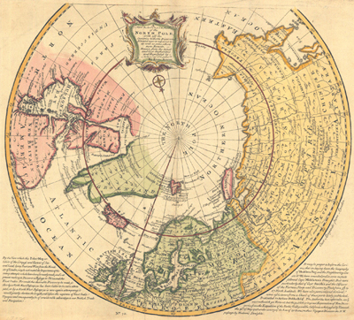
Map by William Moor and Francis Smith, 1746-1747

Mapa of the international polar stations, 1882-83

The North Pole nowadays, with red line that indicates the 10°C (50°F) isotherm in July, sometimes used to define the Arctic region border
Leave a Comment »
Recent Comments
Atka Kevlarsjal on Polar People xarxes on Polar People Atka Kevlarsjal on The Red Book of Russian People… Atka Kevlarsjal on The Red Book of Russian People… Alvaro on The Red Book of Russian People…  fonent el gel (versió en català)
- Mapes tàctils de Grenlàndia
- Tikigaq a Point Hope, Alaska
- Xerrant en Inuktitut
- Les mans fora de l’àrtic
- Segon pas: Kalaallit Nunaat
- Veus de la tundra i la taiga
- Talking Alaska
- Alaska Native Language Center
- Connexió entre llengües de Sibèria i Alaska: noves recerques
- Survival International: els pobles de Sibèria
Create a free website or blog at WordPress.com.
Entries and comments feeds.

Leave a comment